Best Hikes in Custer State Park: Black Elk Peak, Little Devils Tower, and Cathedral Spires
Are you looking for the best hikes in Custer State Park? In this guide, we’ll talk about our favorite Custer State Park hikes – Black Elk Peak, Cathedral Spires, and Little Devils Tower – and how you can combine all three to make one incredible day hike in the Black Hills of South Dakota.

If you’re looking for some of the best hikes in Custer State Park, but also in the Black Hills of South Dakota in general, then we have three good ones for you! These hikes will have you walking among rocky spires, climbing mountains, and even doing a bit of fun rock scrambling.
So, what are the Custer State Park hikes that we love so much?
Black Elk Peak is the most popular hike in Custer State Park and is the highest point in South Dakota!
Cathedral Spires is a nice, short, and pretty easy hike into a valley of towering rock spires that are like nothing we’ve ever seen before.
Little Devils Tower is a super fun trail involving some brief rock scrambling that leads to my favorite view in all of Custer State Park!
The best past about all of these Custer hiking trails is that they are located right next to each other, which means…if you want the absolute best hike in the Black Hills, then we highly suggest you combine all three of these amazing Custer State Park trails into one epic day hike!
This is exactly what we did, and it was our favorite day in the Black Hills of South Dakota. In this guide, we’ll talk about each of these three Custer State Park hikes separately, letting you know how to get to them and what to expect on the trail. But we’ll also share how to combine these three trails to make for one incredible Custer State Park day hike if you think you’re up for it!
In this Custer State Park hiking guide:
About Custer State Park

There’s a good chance you’ll see lots of wildlife in Custer State Park!
Custer State Park is a 71,000 acre park located in the Black Hills of South Dakota. It holds an incredible collection of scenic drives, epic hikes, and awesome wildlife viewing opportunities that is said to rival that of neighboring national parks! Now that’s saying something!
With its close proximity to other popular attractions in the Black Hills, such as Mount Rushmore and Wind Cave National Park, Custer State Park is definitely a must stop on any South Dakota road trip itinerary.
Best Hikes in Custer State Park

Epic views await you from the trails in Custer State Park!
One of the very best things to do in Custer State Park is to hike! Custer State Park hiking trails are fun, rugged, and lead to some epic views of the surrounding landscape that will make you feel like you’ve been transported right out of South Dakota.
While there are plenty of Custer hikes to choose from, we loved three in particular that we wanted to share with you: Black Elk Peak, Cathedral Spires, and Little Devils Tower. And for the most epic day hike in the Black Hills, you can combine all three of these Custer State Park hiking trails! And we’ll show you how…
So, let’s get into each of the Custer hikes in more detail. We’ll first go over some general information about each of these hikes in case you wanted to do any of them on their own. Then we’ll go over how to combine them all to get the best bang for your buck on the trails!
Custer State Park Hiking Map
Below is a map of the trails in Custer State Park near the Sylvan Lake area, which outlines all the best Custer hikes we will be talking about here. Use this as a reference as we describe the hikes later!

A map of Custer State Park hiking trails near Sylvan Lake, taken from the South Dakota State Parks website. The Custer hikes we will be talking about in this guide are Black Elk Peak (via trail #4 and trail #9), Cathedral Spires, and Little Devils Tower.
How to Hike Black Elk Peak in Custer State Park

The fire tower at the summit of Black Elk Peak in Custer State Park
Black Elk Peak is an extremely popular hike in Custer State Park, not only for its amazing summit views, but because those who reach the summit have the bragging rights of having climbed to the highest point in South Dakota, standing at 7,242 feet!
But something even cooler? Black Elk Peak is not only the highest peak in the state, but it’s the highest point east of the Rockies and west of the Pyrenees! That’s pretty crazy.
But despite having such a daunting claim to fame, the hike to Black Elk Peak is surprisingly accessible, and doable for many people. The trails to the top are often filled with people of all ages and hiking abilities.
Let’s go over some of the details and things to expect of the Black Elk Peak hike!
Where is the trailhead for Black Elk Peak?
There are actual multiple trails that go to the Black Elk Peak summit, and multiple trailhead options. But they all lie along one of the most famous scenic drives in Custer State Park…the Needles Highway.
This highway is a 14 mile route through the heart of Custer State Park. It has amazing views of the rocky spires prevalent in this area, and also gives access to many of the best hikes in Custer. However, it’s important to note that this highway has two very picturesque, but narrow, rock tunnels which inherently create vehicle limitations for driving this road. Be sure to check out our Custer State Park Guide to read more about driving this highway and the size restrictions.

One of tunnels you’ll have to drive through on the way to several hikes in Custer State Park, including the Black Elk Peak trailhead!
Here are the main trailheads for the Black Elk Peak hike that can be found along the Needles Highway:
Trail #9: This is the most popular, and most direct, route to the top of Black Elk Peak. It’s found at the Sylvan Lake parking lot, beginning right across from the footbridge to the swimming area.
From here, it’s a 6.6 mile round trip hike to the summit with about 1400 feet of elevation gain if you do this as an out and back hike.
Trail #4: Another popular route to Black Elk Peak, this trailhead is also found at Sylvan Lake, in the southeast corner of the day use parking lot.
From here, it’s a 7 mile roundtrip hike to Black Elk Peak and back with about 1400 feet of elevation gain.
Cathedral Spires Trailhead: Located along a hairpin turn on the Needles Highway, this trailhead is the main gateway for the Cathedral Spires trail. However, you can also access trail #4 and Black Elk Peak from here. It’s a great starting point if you’re looking to combine all three of these awesome Custer State Park hikes, and is where we started!
The Little Devils Tower Trailhead: Just down the road from Sylvan Lake (one mile east on the Needles Highway) is a small pull-off for the Little Devils Tower Trailhead. This is the shortest trail to Black Elk Peak as it cuts off some distance along Trail #4 from Sylvan Lake.
How long is the hike to Black Elk Peak?
As you can see above, this depends on what trail you take, but expect anywhere from about 6.5 to 7 miles. How long it takes to hike Black Elk Peak depends upon your own individual hiking pace, but plan for about 3-5 hours, with time enjoying the views at the summit.
How hard is the Black Elk Peak hike?

Along the trail on the Black Elk Peak hike in Custer State Park
We don’t think there is anything too challenging about the Black Elk Peak hike. It’s long but is a gradual uphill hike, with some steeper and rockier sections only towards the top. I think the thing that will challenge some people is just the length if you aren’t used to longer hikes, but for the seasoned hiker, hiking to Black Elk Peak should be a breeze.
How to Hike to Little Devils Tower in Custer State Park

From the Little Devils Tower hike in Custer, you’ll get an amazing view of Black Elk Peak and the Harney Fire Tower!
Even though Black Elk Peak is the more well-known of the two, Little Devils Tower was my favorite hike in Custer State Park! Its 360 degree views of the area over both the Cathedral Spires and Black Elk Peak were breathtaking, and we spent a considerable amount of time on this summit just enjoying the scenery around us. Plus, the trail had a few fun rock scrambles to keep things interesting!
Here’s some good-to-know information about hiking to Little Devils Tower in Custer State Park.
Where is the trailhead for Little Devils Tower?
Similarly to Black Elk Peak, you can start the hike to Little Devils Tower from multiple trailheads. The most direct trailhead is the Little Devils Trailhead located 1 mile east of Sylvan Lake on the Needles Highway. However, you can also start your hike from Sylvan Lake, making sure to take trail #4 (not #9). Along the #4 trail to Black Elk Peak, there will be an intersection where you’ll take a left to continue up to Little Devils Tower instead.
You can also start at the Cathedral Spires trailhead if you wish to combine Cathedral Spires with Little Devils Tower.
How long is the hike to Little Devils Tower?
How long it takes to hike to Little Devils Tower depends on where you start your hike and what you want to combine the hike with.
Devils Tower alone: From the Little Devils Tower Trailhead, this is a 2.6 mile hike with 600 feet of elevation gain. From Sylvan Lake, it’s a 3.6 mile roundtrip hike with about 750 feet of gain.
Hiking Black Elk Peak and Little Devils Tower: If you want to combine both of these amazing Custer State Park hikes, it will be about 7.8 miles with 1700 feet of elevation gain starting from Sylvan Lake.
Hiking Cathedral Spires and Little Devils Tower: If you start your hike at the Cathedral Spires trailhead, hiking to the spires is an easy add-on.
How hard is the hike to Little Devils Tower?
The hardest part of the Little Devils Tower hike comes at the very end. Here, you will encounter some minor rock scrambling and walking up some steep rock faces. We didn’t find it hard, just fun! But we definitely encountered a lot of people on the trail who were a bit uncomfortable or just weren’t expecting these trail elements! Some people turned around and some just took their time tackling the obstacles.


How to Hike the Cathedral Spires Trail in Custer State Park

Walking among the spires on the Cathedral Spires hike in Custer
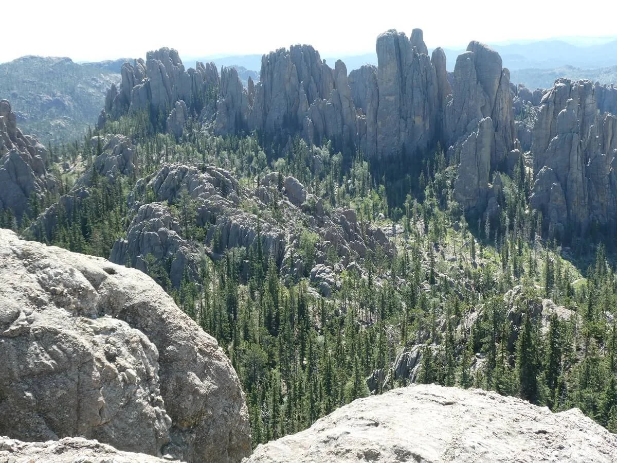
The Cathedral Spires trail is a super unique hike in Custer State Park. In fact, it was Kevin’s favorite part of the whole Black Elk Peak-Little Devils Tower-Cathedral Spires loop hike!
The views of the rock spires towering above you are incredibly unique and something we haven’t quite seen anywhere else!
The best part is that the hike to Cathedral Spires is pretty short and easy, making it a great accessible hike in Custer State Park.
Here are the details about how to hike to the Cathedral Spires in Custer State Park.
Where is the trailhead for Cathedral Spires?
The trailhead is located on a hairpin turn along the Needles Highway. Parking here is pretty limited, so you want to make sure you get here pretty early. We got there at 9:15am on a Sunday and all the official spots were taken, but you can park along the road…we were the first ones that needed to do so. But when we got off the trail later in the afternoon, cars were lining the road.

Parking can get a little tight for the Cathedral Spires hike in Custer
How long is the hike to the Cathedral Spires?
The hike to Cathedral Spires is pretty short, just 1.8 miles round trip!
How hard is the hike to the Cathedral Spires?
The Cathedral Spires hike is short but considered a moderate hike by the park because it has some steep (but brief) rockier sections that you might find you have to take your time on, especially on the way back down.
The Best Hike in Custer State Park: Hiking the Black Elk Peak - Little Devils Tower - Cathedral Spires Loop

The Cathedral Spires hike in Custer State Park has some of the most unique views!
If you’re like us and are having a tough time choosing which Custer State Park hike you should do, then you’re in luck! You can easily combine all three of these Custer trails to make one incredible day hike in the Black Hills.
How long is the Black Elk Peak – Little Devils Tower – Cathedral Spires Loop?
Here are our hiking stats for the entire Black Elk Peak- Little Devils Tower- Cathedral Spires hike. This is based on starting and ending at the Cathedral Spires trailhead.
Distance: 7.98 miles
Elevation Gain: 1,909 feet
Time: 5-6 hours. It took us just about 6 hours to complete this entire loop, but that was with a lot of down time on each summit. Definitely give yourself some padding time to enjoy the views on this Custer hike!
Trail profile: This elevation profile is based on starting at the Cathedral Spires trailhead and visiting the spires, then Little Devils Tower, and Black Elk Peak last.
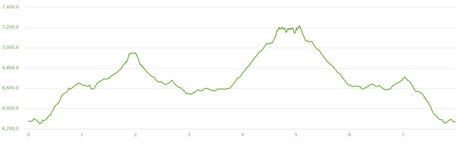
Difficulty: This Custer hike combines all the difficulties of each trail mentioned above. Really, the most difficult part is the scrambling on the Little Devils Tower trail. Other than that, just be prepared for a relatively long day on the trails (which is never a bad thing!).
Black Elk Peak Trail Map

A satellite view of the Cathedral Spires-Little Devils Tower-Black Elk Peak hike in Custer
Where to start the Black Elk Peak – Little Devils Tower – Cathedral Spires Loop
The shortest way to complete this Custer hike is by starting at the Cathedral Spires trailhead. You can begin at Sylvan Lake (by taking trail #4 to be able to access the two spur trails to Little Devils Tower and Cathedral Spires), but it will add about an extra mile to the overall hike.
What to expect on the Black Elk Peak – Little Devils Tower – Cathedral Spires Loop Trail
Here’s a breakdown of the different sections of this epic Custer State Park hike, so you can know what to expect on the trails!
The hike to Cathedral Spires
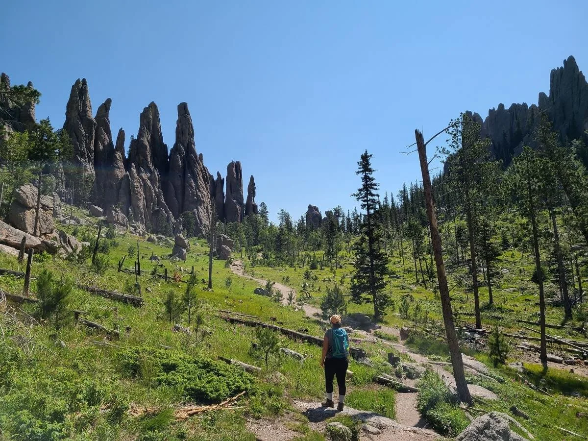
From the Cathedral Spires trailhead, this Custer State Park hike starts off relatively flat through a sparse forest with views of the rocky spires in the distance.


Soon, the trail will start to ascend. This is the section of the Cathedral Spires Trail that gives it its rating as moderate, but it is pretty brief and very doable. Some spots of the trail get a bit steep and rocky, which you might find a little tricky to navigate on the way back down, but this doesn’t last too long. On the way, there are some cool tall spire-like rocks along your side that are a preview of what’s to come!


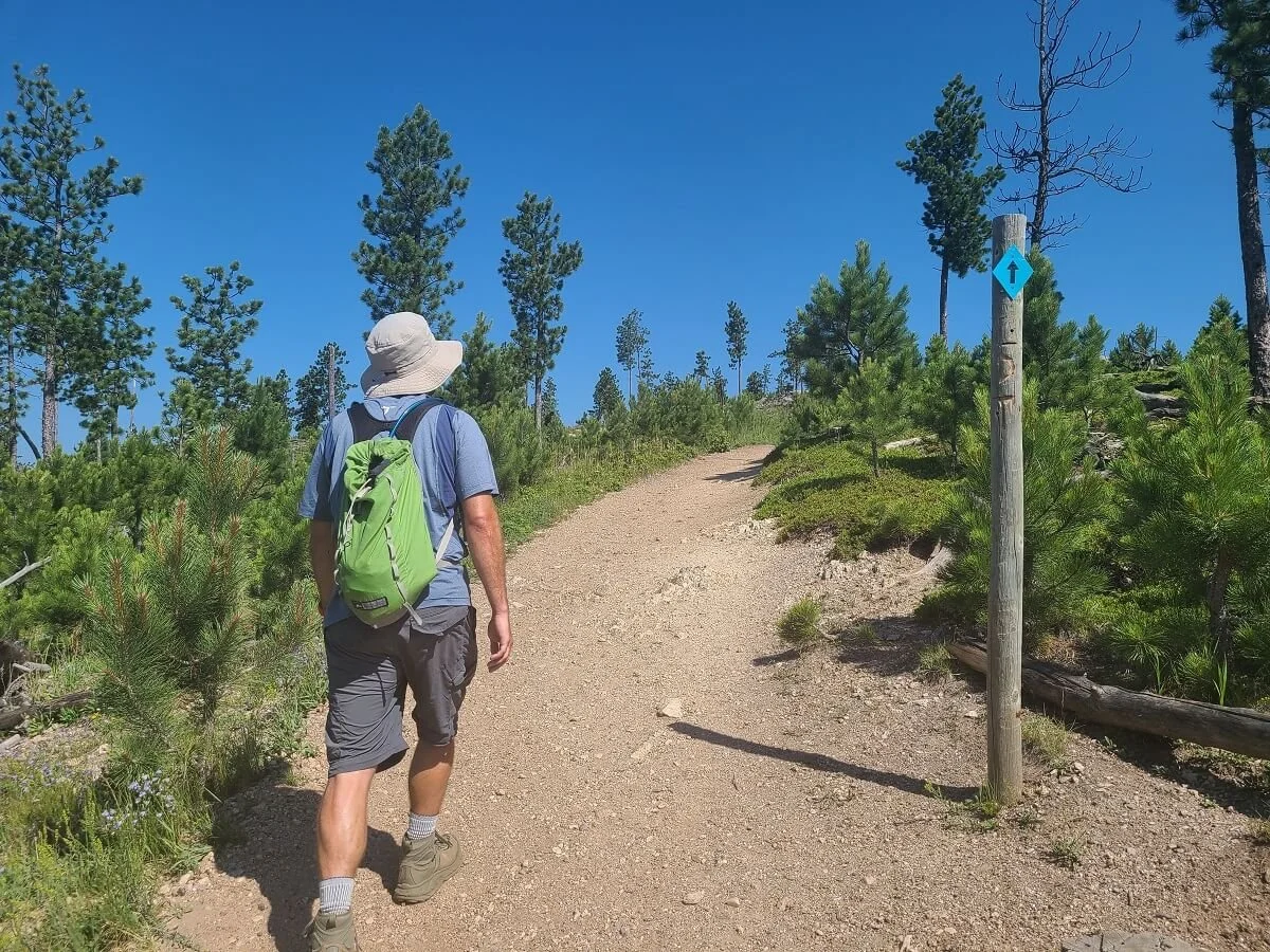
Once the trail flattens out and becomes dirt again, you’ll see the spires ahead. You’ll come to a trail junction. At this point, continue straight towards the spires.
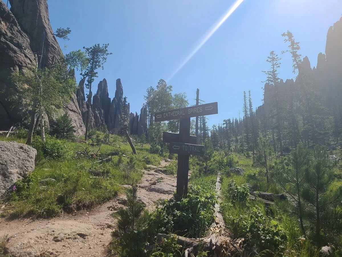
Trail signs along the Cathedral Spires hike in Custer
After making a turn around some tall boulders, you’ll come to the best views of the Cathedral Spires (and Kevin’s favorite spot!). A picturesque flat trail will take you towards and through these spires, and it’s definitely pretty cool to see them towering above you here.
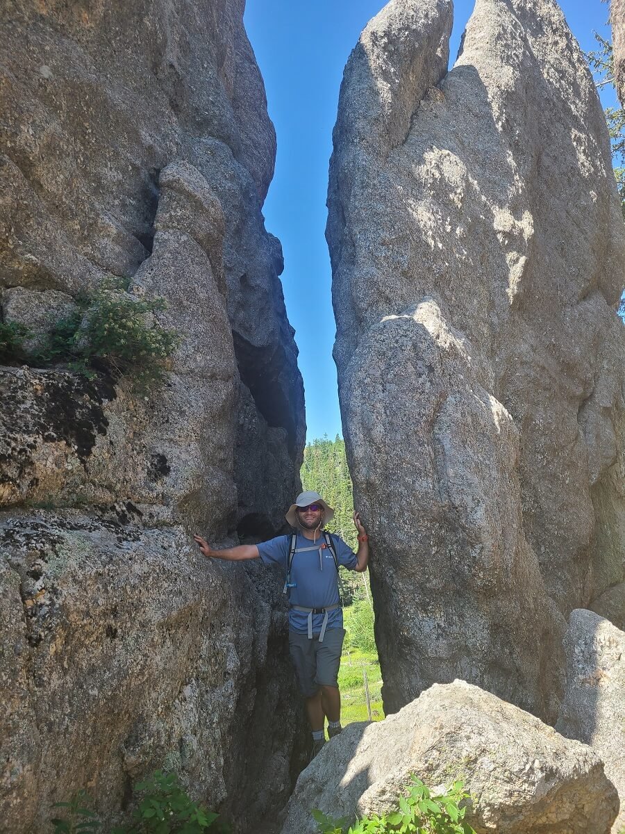

One of the coolest views on this Custer State Park hike!


Just past the spires, the trail ends. We read in a few places that it’s not necessary to walk to the end of the trail because it’s pretty anticlimactic and viewless, but we just had to for completeness sake! And we do agree…it’s a bit uneventful.
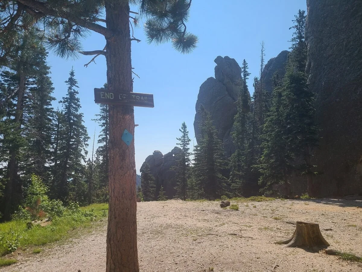
The end of the Cathedral Spires hike in Custer
When you’re done marveling at the spires, head back to the last trail junction you passed.
The hike to Little Devils Tower
The next portion of this Custer hike was our favorite!
At the junction when coming from the spires, take a right (the trail sign will be pointing towards trail #4), instead of going back to the trailhead. This short roughly .2 mile spur trail is a quick and steep dirt climb to connect up to trail #4 (the Little Devils Tower Trail).

A short section of steep trail on the way to the Little Devils Tower
At the next junction (the end of the spur trail), take a left to hike Little Devils Tower next (taking a right will lead you to Black Elk Peak).

The trail junction with Trail #4 - left takes you to Little Devils Tower and right takes you to Black Elk Peak!
On this trail, it will be another quick walk (about .2 miles) to the next junction, but it’s a flat and easy forested part of the trail. There is one cool viewpoint that will be on your left (you’ll see a bench there). From here, we got our first look at Black Elk Peak and its fire tower looming in the distance!

Just a bit further down the trail, you’ll reach the junction for the spur trail up to Little Devils Tower on your right. This junction is pretty hard to miss, as it’s a pretty obvious fork in the trail. The Little Devils Tower spur trail is marked with a post that has a blue diamond and the letters LTD. From here, it’s just 0.4 miles up to the summit - but there’s a bit more to it!
The start of the trail to Little Devils Tower - note the pole inscribed with “LDT”
The start of the spur trail is pretty easy and gradually uphill. It’s a pretty open trail so you get great views early on. Ahead, you can see the summit of Little Devils Tower. A cool thing that we noticed here, too, was that the sand on the trails up here seemed to sparkle and glimmer in the sun.

Looking at the summit of Little Devils Tower in the distance…but first you’ll have to climb up those rocks to get to it!
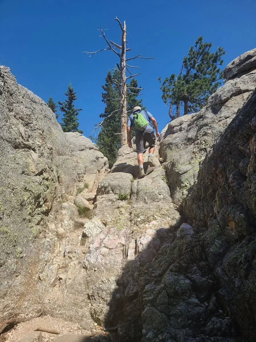
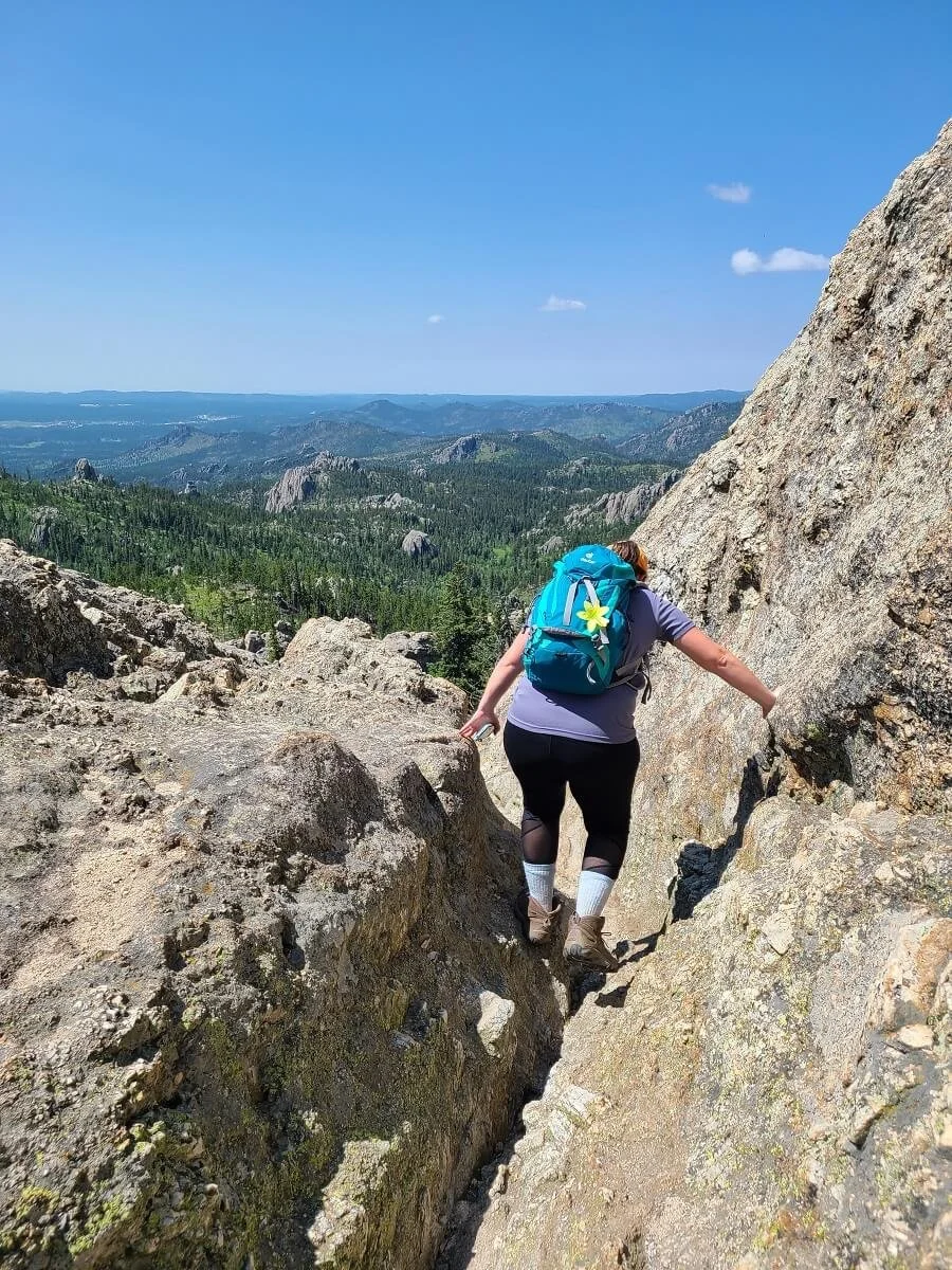
Towards the back half of the Little Devils Tower trail, the path will begin to get a bit rockier as you ascend. Pretty soon, you’ll have to navigate a few sections of minor rock scrambling. Blue arrows painted on the rocks will guide your way through the rocky maze, so be sure to keep your eyes out for these!


View along the Little Devils Tower hike in Custer!
The scrambles are pretty short sections, and we thought they were fun! But there were definitely people struggling and deciding to turn around here, so we just wanted to give you a heads up on what these features look like!
You’ll also have to navigate up and around some steeper rock slabs of the trail as well.

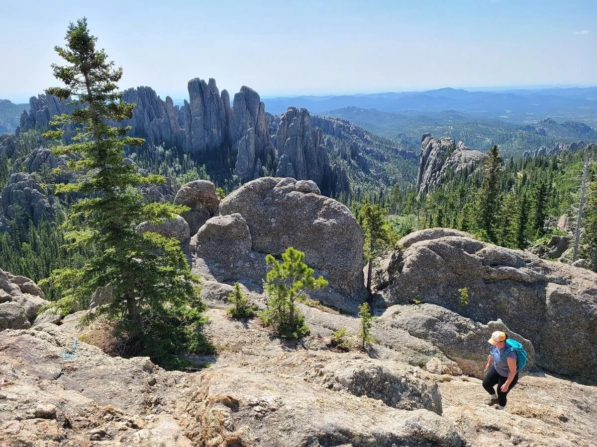
One final push will pour you out onto the Little Devils Tower summit. We loved this view! It’s a complete 360 degree panoramic view of the landscape, including looking down on the Cathedral Spires (which look so cool from above!), and over at the giant summit of Black Elk Peak. You can even see the fire tower on the peak.

The Little Devils Tower hike had our favorite views in Custer!
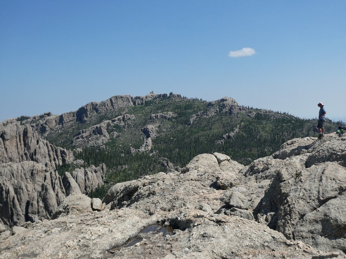
From the summit of Little Devils Tower, you get a perfect view of Black Elk Peak and the Harney Fire Tower…where you’ll be going next on this Custer State Park hike!
You even get views back over the Cathedral Spires!
We stayed up here for a while and eventually we had some brief moments where we had the summit all to ourselves, just enjoying the views. These were my favorite of the entire Custer hike, even more so than those from Black Elk Peak!
When you’re done, navigate the 0.4 miles back to the junction on Trail #4.
Looking back down the rock slab at the top of the Little Devils Tower hike

The hike to Black Elk Peak
Now it’s time for the grand finale of this Custer hike…the high point of South Dakota!
Back at the junction for Trail #4, take a left and continue back towards the Cathedral Spires junction that you came up, but at this junction, keep going straight to complete the Black Elk Peak hike.
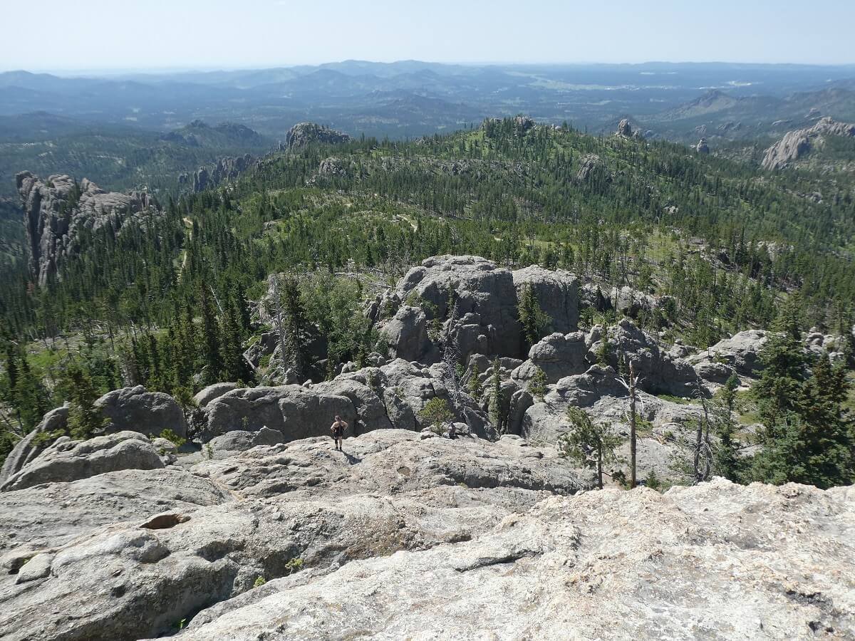
Along this part of the Black Elk Peak trail, you’ll walk through a nice forested section and descend a bit before you start your climb up the peak. Along the way, you’ll be treated to cool views of the spires to your right.

Heading up the trail to Black Elk Peak in Custer
Eventually, you’ll enter the Black Elk Wilderness, marked by a wooden sign, and a little bit after that, a permit station. These permits to hike to Black Elk Peak are free, but required. Make sure to stop here and fill out a permit and keep it on you for the hike!

The permit station along the Black Elk Peak hike in Custer
From here to the Black Elk Peak summit, you’ll pass a few more trail junctions. The first will be a junction for trail #3 to the right (stay straight!), and shortly after for trail #7 (bear left to stay on course). Trail signs along the way will make the hike to Black Elk Peak pretty clear.
Overall, the hike up to Black Elk Peak consists of just a steady gradual ascent through a sparse forest. There’s nothing too challenging about it. The higher you go, the more the views open up. You can even see the backside of Mount Rushmore from here!

Pretty wildflower views along the Black Elk Peak hike

The typical steepness towards the top of the Black Elk Peak hike in Custer State Park

If you look closely, you can see the amphitheater building for Mount Rushmore in the distance, and to the left of that is the side of Mount Rushmore!

Enjoying the views from the Black Elk Peak hike
Eventually, you’ll come to the junction with Trail #9 (the alternate route to Black Elk Peak from the Lake Sylvan trailhead), which you’ll join up with here for the last stretch to the summit. Trail signs along the way make it pretty clear to know the way to take to get to the top.
Soon after, you’ll see the tower above you so you know you’re close. But up here, the trail to Black Elk Peak gets a little bit steeper with lots of rock steps. But it also has some fun features - a small rock passage you can walk through, and some cool metal stairways.


Heading up the metal staircases just before the Black Elk Peak summit
Just past the metal stairs, there is one final stone staircase that leads you right up to the Harney Fire Tower on the summit of Black Elk Peak (yay! You’ve made it to the highest point in South Dakota!)

The final staircase to Harney Fire Tower at the top of Black Elk Peak
Head into the tower to walk out onto a viewing platform overlooking the summit or head up the stairs to get a slightly higher but 360 degree vantage point of the entire area.

The steep narrow staircase in the Harney Fire Lookout on Black Elk Peak
To explore the rest of the huge summit area, take the stairs inside the fire tower to the lower level to exit the tower and get easy access to the rest of Black Elk Peak. A narrow stone staircase will lead you down to the massive rocky summit.

The stairs behind the fire lookout to access the rest of the Black Elk Peak summit
There will likely be lots of people up here, but the area is so huge that everyone can spread themselves out, and there are plenty of views everywhere you go up here!

Enjoying the views from the Black Elk Peak summit…the highest point in South Dakota!


Looking back at the Harney Fire Lookout from the other side of the Black Elk Peak summit
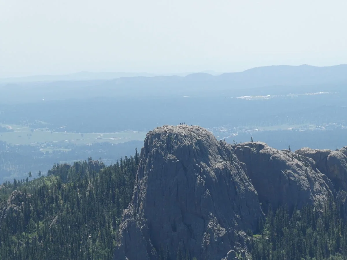
Can you see where Little Devils Tower get its name? If you look closely, you can see people standing at the summit!
When you’re done enjoying the awesome South Dakota views, head back down, following the trail back the way you came all the way to the Cathedral Spires trail junction (remembering to get back on trail #4 at the first junction you come to!).
Head back down the short 0.2 mile connector trail to the spires and hike back to the Cathedral Spires trailhead to complete your epic Custer State Park day hike!
Best Time to Hike in Custer State Park

It’s generally best to hike in Custer State Park between late spring to early fall. Outside of this time frame, you might experience very cold and windy weather, and possible snow on the trails.
Also, the road to get to the trailheads for all these Custer State Park hikes (the Needles Highway) closes in the winter (from the first snowfall through to April 1st). While you can still walk or ski the road, it will make hiking in Custer State Park a much more difficult task. If you do want to hike in Custer in the winter, make sure to bring microspikes and good winter gear!
The summer is the peak time to visit and hike in Custer State Park, and it does get crowded. It can also get pretty hot with an intense summer sun.
Especially in the summer, afternoon storms that bring lots of rain and/or hail and wind are common, so be sure to keep an eye on the forecast and don’t plan to be on any summit with bad weather in the forecast. Both Black Elk Peak and Little Devils Tower are completely open and exposed summits so you definitely don’t want to be hiking out there during any sort of thunderstorm.
Do You Need A Permit to Hike in Custer State Park?

It doesn’t directly cost anything to hike Black Elk Peak, Cathedral Spires, or Little Devils Tower, but there are some things you should know regarding fees and permits before you hit the trails in Custer State Park.
Custer State Park entrance fee: The park does charge a fee to enter, which is $20 per vehicle and is good for 7 days. You can purchase this at any of the entrance stations in the park, including one you’ll encounter on your way to the Sylvan Lake area, where the trailheads for these Custer State Park hikes are located. You must display this pass on your dashboard while in the park.
Black Elk Wilderness permits: If you’re hiking all the way to Black Elk Peak, you will eventually cross over into the Black Elk Wilderness, which requires that you have a permit. Permit stations are located right along the trail and they are completely free, so be sure to fill one out and keep it with you for the rest of your hike.
Tips for Hiking to Black Elk Peak in Custer State Park

Here are some additional tips to keep in mind when hiking in Custer State Park to help you have the best day on the trails!
Don’t expect solitude. The Black Elk Peak area of Custer State Park is one of the busiest areas in the park. Even the forest service itself says to not expect solitude, especially along trail #9, the most popular trail to Black Elk Peak, which can see up to 500 people a day in the peak summer season! When we were there in July, the trail in Custer, and the summits, were quite crowded, but most of the time people could spread out since the trail is so long and the Black Elk Peak summit is so big.
Avoid certain times to beat the crowds. We hiked in Custer on a Sunday, which is probably why we saw so many people. Plus, it was July- the peak of summer. Try hiking on weekday or in a shoulder season, like spring or early fall, to avoid crowds. Timing your hike for sunrise or sunset may also allow you to leave some crowds behind, and would make for an epic summit sunrise/sunset view (just don’t forget the headlamps!).
Check trail conditions. Check for any trail closures before you set out on your hike. When we were there, Trail #9 was actually closed for trail maintenance for the week, so we really only had one option to get up to Black Elk Peak!
Bring layers. It might be hot on the start of your hike, but it can be chillier and windier at the summit.
Wear sunscreen and a hat. Especially in the summer, it can be pretty hot and the sun can get quite strong on Custer State Park trails. By the end of our hike, I was definitely feeling the heat and it was slowing me down a bit.
Bring lots of water and snacks!
Wear bug spray. It can get pretty buggy here!
Wear good hiking shoes. Ideally, wear boots with good traction, especially if you plan to hike to Little Devils Tower. This will make the rocky sections much easier.
Check the forecast. Especially in the summer, rain and storms are common in the Black Hills. Don’t plan to be on these Custer hikes if thunder is in the forecast, and pack a rain coat and pack cover just in case.
Don’t feed the wildlife. There will be lots of cute and friendly chipmunks on the summits of these Custer hikes trying to be your friend in exchange for food…but don’t give in, it’s not good for them!
Things to Do Near Black Elk Peak and Custer State Park
We highly suggest spending a bit of time in the Black Hills, and making this Custer State Park hike just one stop on a South Dakota road trip itinerary! There are so many awesome things to do in the Black Hills area that you can spend a full week here and not run out of places to go!
Things to do near the Black Elk Peak hike and close to or in Custer State Park include:
MOUNT RUSHMORE – An iconic American bucketlist spot! Learn what to do at Mount Rushmore and how to plan your time.
WILDLIFE LOOP ROAD – a great place to spot wildlife, especially bison! Check out our Custer State Park guide to learn more.
CAVE TOURS- Take a tour at Wind Cave National Park or Jewel Cave National Monument to visit massive underground caves.
CRAZY HORSE MEMORIAL
BADLANDS NATIONAL PARK – an incredibly scenic National Park filled with epic badlands, fun hikes, and prairie dogs, bison, and bighorn sheep! Learn about all the awesome things to do in Badlands National Park in our comprehensive guide.
SOUTH DAKOTA ROAD TRIP- We have lots more information to help you plan a South Dakota road trip. Feel free to browse all our South Dakota articles to give you ideas and spark your wanderlust!
And to help you plan an epic South Dakota road trip, check out our Black Hills South Dakota itineraries for one day to one week!
Are you planning to hike in Custer State Park? Let us know if you have any questions! If you’ve been, what would you add to the list of best Custer State Park hikes?