How to Drive Deer Park Road in Olympic National Park: The Complete Guide
Have you heard of Deer Park Road in Olympic National Park? This 17- mile backcountry mountain road brings you away from the crowds and into the heart of the Olympic Peninsula by climbing and twisting its way up to panoramic views over the park, but it can be a bit scary and harrowing to drive. In this guide, we’ll go over everything you need to know to drive Deer Park Road in Olympic National Park, including when to go, what to expect, how scary it really is, and more!

Olympic National Park has a stunning collection of diverse landscapes and ecosystems covering much of the Olympic Peninsula. The park is most well-known for its mystical temperate rainforests like the Hoh Rainforest, and for the easily accessible and breathtaking views of the Olympic range from Hurricane Ridge. And while both places are absolutely worth visiting on any trip to Olympic National Park, their popularity comes with crowds, and at peak times, you may find yourself waiting in long lines just to even get into the park!
So, where can you go in Olympic National Park to escape the crowds but still get amazing views? We have one idea for you…head to Deer Park!
Deer Park is a small but quiet high elevation area of Olympic National Park where you can get panoramic views over the Olympic Peninsula that are just as good as those of the neighboring Hurricane Ridge, but without the same crowds. So, what’s the catch?
Well, the catch is that you’ll have to drive Deer Park Road to get there. Deer Park Road in Washington is a 17- mile long road that twists and turns its way up the mountains to the top of Olympic National Park. It gives way to some beautiful views, but we will admit…it can be a pretty scary drive. It’s narrow, full of blind turns, and has a bit of exposure as it carves its way up the mountainside. But at the end of the road, you’ll be sitting at about 5,800 feet in elevation, just below Blue Mountain, and you can take a short walk to its summit to be rewarded with amazing views over the Olympic range and out to the Strait of Juan de Fuca.
Overall, driving Deer Park Road in Olympic National Park is a great way to escape the crowds, have a unique adventure, and get stunning views over the park, but it’s important to know exactly what you’re getting yourself in to and to be prepared. In this guide, we’ll go over everything you need to know to drive Deer Park Road in Washington, including the best time to go, what to expect on the drive, things to do in Deer Park, and more! Let’s get to it!
In this Deer Park Road guide:
Check out more of our guides to help you plan!
30+ Best Things to Do in Olympic National Park (coming soon)
Best Hikes on the Olympic Peninsula (coming soon)
Olympic National Park Itinerary: One to Seven Days on the Olympic Peninsula (coming soon)
The Hoh Rainforest in Olympic National Park: The Complete Guide
How to Visit Hurricane Ridge + Things to Do
Where is Deer Park Road in Washington?

Beautiful alpine views from Deer Park Road- definitely a change of pace from the popular rainforests and beaches along the coast!
The start of Deer Park Road is located on the northern end of the Olympic Peninsula, just outside of Port Angeles (often called the gateway to Olympic National Park). The turn-off for the road is off of WA- 101 (the Olympic Highway that circles the peninsula), just about 6 miles east of Port Angeles and 12 miles west of Sequim.
Here are some distances to the start of Deer Park Road from other popular Olympic National Park spots:
From Hurricane Ridge: 45 minutes (24 miles)
From Lake Crescent: 40 minutes (27 miles)
From the Hoh Rainforest: 2 hours (93 miles)
Deer Park Road itself will bring you 17 miles into the heart of the peninsula to what feels like the top of Olympic National Park!
Deer Park Road map
Here is a map of Olympic National Park (taken from the park brochure) highlighting where Deer Park Road is in relation to other popular park spots.

This map shows the northern portion of Olympic National Park. Popular spots in this area are highlighted and include Lake Crescent, Sol Duc, and Hurricane Ridge. Deer Park Road is found to the east of all these popular locations, right off Highway 101.
Is Deer Park Road in Washington Scary?
I won’t lie, Deer Park Road had my heart skip a beat on more than one occasion, but it might not be for the reason you’d think!
Deer Park Road in Washington is a true backcountry mountain road, climbing nearly 5,000 feet to the base of Blue Mountain in Olympic National Park. While the last 8 miles of Deer Park road are gravel and steep in places, it’s actually pretty well- maintained. It does get bumpy and rutted at times, and more so as you reach the top, but it’s not the worst road we’ve ever been on by any means.
One aspect that does make Deer Park Road a bit scary to drive is the fact that there is a bit of a drop- off on one side of the road throughout much of the drive. For a while, the drop- off is kind of disguised by the trees lining the road, but it certainly is there. Once you break tree line, that drop off becomes very apparent!

A typical view towards the top of Deer Park Road. This was taken as were driving down, so the drop-off is to our left.
This, combined with the fact that the road is quite narrow, can be quite harrowing…particularly with two-way traffic. It can be a bit scary when a car is coming from the opposite direction and it seems that there is no way to pass each other. In some places, the road is simply not wide enough. There are quite a few small pull-off areas dotted along the road and if you’re lucky, you’ll be at one at the right time. Otherwise, you may have to do some backtracking to a previous pull-out that you can use to allow the oncoming car to get by.

A narrow portion of Deer Park Road
Speaking of oncoming traffic…
Here’s the scariest part of driving Deer Park Road in Washington…at least for me! Deer Park Road is not only narrow, but it is super twisty and winding. For pretty much the entire way, the road is made up of small turns going back and forth. There are some bigger hairpin-like turns here and there, but for the most part, the road quite literally wiggles its way up the mountainside. And because of that, there are so many blind turns. It becomes almost impossible to see any oncoming cars in large portions of the road! This was the scariest part of the drive for me and kept me on edge… there were a few times where a car would suddenly appear just as we reached a corner and my heart would jump. Fortunately, the road wasn’t busy, so this only happened a few times…which was more than enough for me!

A commonly-encountered blind turn along Deer Park Road- this is what made this drive so scary!

This image is taken from Google Maps and shows just how winding and twisting Deer Park Road gets!
We actually drove Deer Park Road as a sort of “warm up” to Obstruction Point Road, also in Olympic National Park and once labeled as the most dangerous road in Washington State! However, after driving Obstruction Point Road the next day, I still thought that Deer Park Road was scarier! Maybe it’s because I was already primed with what to expect, so Obstruction Point Road didn’t seem as bad as I thought it would be, but I really think the twisty and turny nature of Deer Park Road with all of its blind turns really got to me!
Overall, our advice would be to take it slow and cautiously, and have a confident driver behind the wheel who isn’t easily phased by mountain road exposure.
Check out our guides to some other mountain road adventures:
Obstruction Point Road in Olympic National Park
Titus Canyon Road in Death Valley National Park
How Long Does it Take to Drive Deer Park Road in Olympic National Park?

If you look carefully, you can see Deer Park Road winding its way through the trees as it heads up the mountain
From the turn off on WA- 101 to the top of Deer Park Road, it’s about 17 miles and took us about 40 minutes to drive. Only the last 8 miles are gravel, but the first half of the drive is still winding and narrow, and you can’t (or won’t want to) go too fast. 15-20 mph is the average speed you’ll likely be going.
Once at the top in Deer Park, you’ll see below that there aren’t too many things to do (though trust us, it’s still worthwhile!) unless you are planning to start a longer backpacking trip through the park from here. Otherwise, a visit up here can be pretty quick. We spent about an hour or so before hopping back in the car and making the drive back down. So overall with the drive up and down, we spent about 2.5 hours for the whole Deer Park Road experience.
Best Time to Drive Deer Park Road in Olympic National Park

Beautiful summer views from the top of Deer Park Road
Because of its high altitude, Deer Park Road in Washington closes in the winter due to snow. Typically, Deer Park Road is open from mid-June to mid-October, but be sure to check road conditions and status just to make sure it’s open before you head out.
Because of the conditions of Deer Park Road, we also definitely don’t recommend driving this in the dark, or when the road is wet and slick. If you want sunrise and sunset views from the top, we recommend driving up during daylight hours and camping in Deer Park (we talk more about camping below).
And here’s another tip for driving Deer Park Road: If you’re a little nervous and want to minimize the chances you’ll run into oncoming traffic, try to drive the road on a weekday. We drove Deer Park Road on a Monday in July, and there were only a handful of cars that we had to maneuver by. I’m sure weekends, especially in the summer, are busier (still not crowded, though!).
Do You Need a 4WD Vehicle to Drive Deer Park Road?
A 4WD high clearance car isn’t necessary to drive Deer Park Road, and we think it would be doable in a normal car. Just take it slow, watch the road carefully for potholes and ruts, and you should be fine.
That said, we had a truck and Kevin particularly used and liked having the 4WD feature on the way up to avoid the back tires from sliding as we climbed up the gravel road. Having the functionality is recommended and probably just makes the drive a bit easier.
And this probably goes without saying, but don’t take any larger vehicles, like RVs or trailers, down this road…it’s way too narrow and twisty for those!
Is There a Fee to Drive Deer Park Road in Washington?
Deer Park Road enters Olympic National Park after about 9 miles. The last 8 miles of gravel road is entirely within the park. While there is no entry gate along the road, you are still required to have and display an Olympic National Park pass on your dash, which costs $30 per car (good for 7 consecutive days) and can be purchased at one of the other park gates at the more popular areas (like at Hurricane Ridge or the Hoh Rainforest).
Driving Deer Park Road in Washington: Our Experience
Here, we want to share our experience driving Deer Park Road in Olympic National Park to show you what you can expect and if you want to tackle the drive!
After turning off of WA- 101, Deer Park Road starts off on a well-maintained, smooth, paved road through the forest. It’s a pretty drive through the trees, with some brief views out to the surrounding forest-covered mountains, but already the road is pretty narrow and twisty. It’s not scary yet, though, so enjoy this part!

The first half of Deer Park Road is paved, with occasional views like these. It’s not too bad yet!
After about 9 miles of paved road, you’ll reach the National Park boundary, and Deer Park Road turns to gravel as you’re greeted by a sign warning you of the remaining 8 miles ahead. Though it is gravel and a bit bumpy, overall the road actually seems to be pretty well-maintained, and doesn’t get too rough until near the top.

Crossing over into Olympic National Park and transitioning onto the unpaved and scarier half of Deer Park Road!
Now in the National Park, the narrow road twists and turns through a thick lush forest on either side. And it twists and turns a lot. It’s almost as if the road is wiggling its way up the mountain. And with these twists and turns comes lots of blind turns where you really can’t see the oncoming traffic. As I mentioned above, this was definitely the scariest part of Deer Park Road for me! Luckily, the road wasn’t busy so there weren’t too many cars coming in the opposite direction, but when they did suddenly appear around those blind turns, I think both of our hearts skipped a beat or two! Fortunately, this happened where it was possible to move over just enough to slide past each other, or one of us had a small pull-off we could use.

Deer Park Road as it winds through the forest

The narrow Deer Park Road just barely fits two-way traffic
As you continue driving the gravel road, you might not notice it as first, but the road develops a drop-off on one side. At first, it’s pretty well-disguised by the thick trees lining the road.

You can tell here that a drop-off is forming to the right of Deer Park Road, with a blind turn ahead!

A view of Deer Park Road as we drove back down
However, as you climb, the trees begin to thin out, and the exposure on Deer Park Road becomes much more evident. You’ll quickly realize you are truly driving a mountain road cutting across a mountain slope, with a stark drop on your right, and a dirt cliff to your left. It’s a bit hard to capture the exposure and blind turns of the road in pictures, so hopefully our pictures are giving you some idea, but trust us when we say that they are both there!

More exposure higher up on Deer Park Road, but the views really open up!

Beautiful views from Deer Park Road, but remember to keep your eye on those blind turns!
Once out of the tree line, this is where the views along Deer Park Road start opening up and getting good! As the trees thin and eventually start to disappear, you’ll be treated to open views of the distant snow-topped peaks.

Mountain views from Deer Park Road
As you continue along this exposed part of Deer Park Road, it continues to be narrow, winding, and dusty, and does get a little bit rougher up here with more bumps, washboarding, and ruts in the road. The gravel road portion of the drive is only 8 miles, but it’s a long 8 miles and the bumps, twists, and turns definitely start to get a bit old!

Near the top of Deer Park Road
As you get closer to Deer Park at the top, you’ll see signs for the Obstruction Point trailhead, but stay straight to head towards the Deer Park Campground and keep following the main road.
Just before the top, there will be a large pull-off where you can pull over, get out and stretch your legs, and take in the views.

Beautiful views over the Olympic Mountains from Deer Park Road
After 8 miles of somewhat tense driving, what a relief it was to finally see the parking lot! Deer Park Road ends in a small lot at the base of Blue Mountain, and the views from here are already great. When we got there, there were only three other cars, and we were excited to get out and do some exploring away from the crowds.

A view of the small parking lot at the top of Deer Park Road in Olympic National Park
Deer Park Road in Washington: Things to Do
So you made it to the top of Deer Park Road. Congratulations, you did it! Now what?
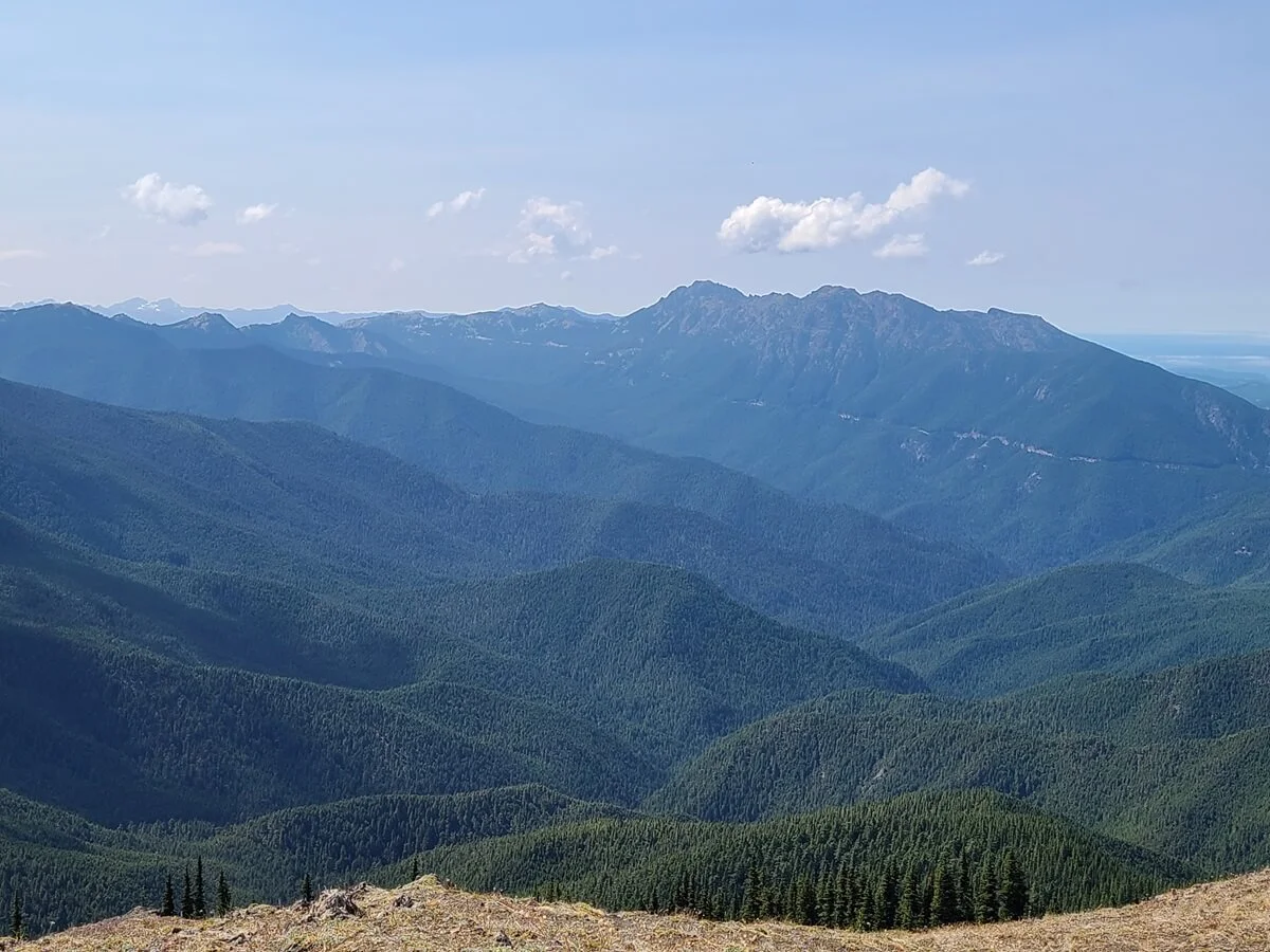
Well, we’ll be honest with you…there’s not that much to do up here. But that’s okay! The main reason for driving Deer Park Road is for the experience of driving the road…and for the views you can get at the top. From up here, you can see out to Port Angeles and the Strait of Juan de Fuca, and also out to the Olympic Mountain range, with Mount Olympus itself peeking up behind the foothills. The views are great from up here, so have a picnic, relax in the solitude, and soak it all in!
But here’s a brief warning: The only downside of being up here? The flies. The whole area was swarming with them! So just be prepared for that.

The view from the parking area of Deer Park Road looking North towards the Strait and Port Angeles
But the best thing to do at the end of Deer Park Road is to hike the Rainshadow Trail to the top of Blue Mountain. Blue Mountain is probably the easiest summit you will ever hike to! The Rainshadow Trail is an easy half mile interpretive loop that brings you up less than 200 feet from the parking lot to the Blue Mountain summit, which sits at 6,009 feet in elevation. From up here, the views are panoramic over the Olympic Peninsula. You can see out to the Strait, over the Olympic Mountains, and if you look closely, you can even see Hurricane Ridge Road weaving up the mountainside in the distance.
So, let’s get into a brief description of how to hike the Rainshadow Trail on Blue Mountain!
Hiking the Rainshadow Trail on Deer Park Road
The Rainshadow Trail starts right from the top of Deer Park Road. At the start of the trail, you can grab a map and interpretive guide for the hike (unfortunately, there were none left when we were there).

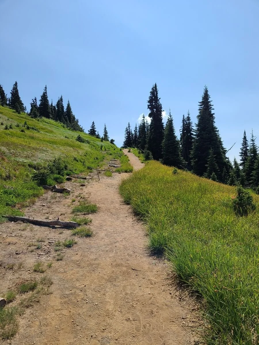
The start of the Rainshadow Trail as it makes its gradual ascent to the top of Blue Mountain
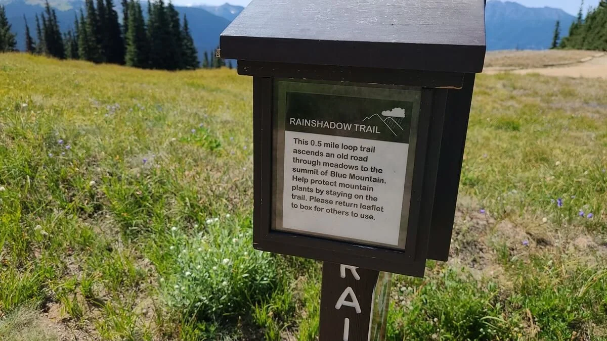
You can grab a trail guide at the start of the Rainshadow Loop
The trail starts off by climbing briefly through meadows and quickly reaches the large summit. A short side trail leads to an amazing viewpoint over the Olympic range. From up here, you can also look down at the top of Deer Park Road making its last few turns before the parking lot.
The view of the easy climb to the top of Blue Mountain in Olympic National Park
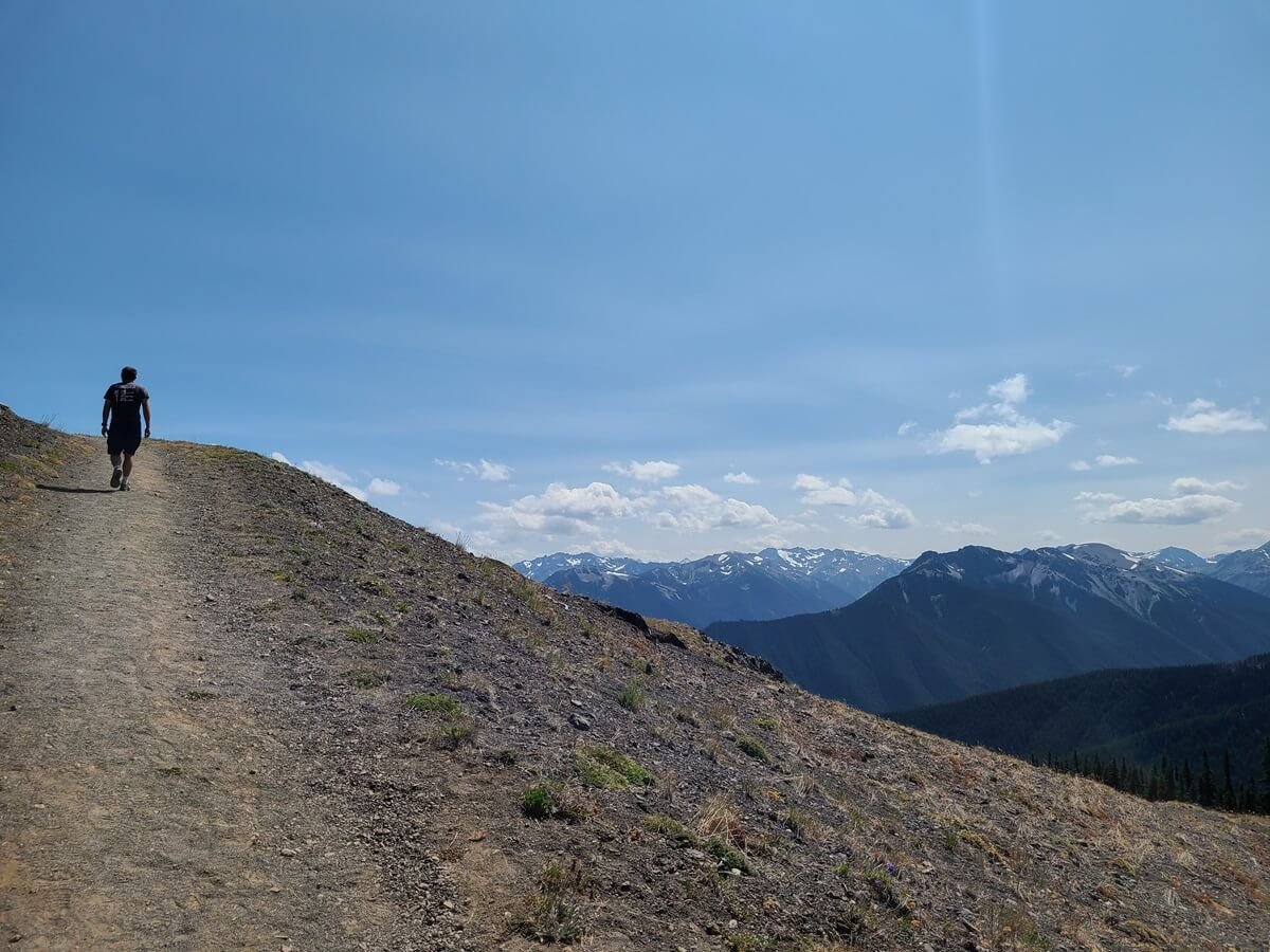
Towards the top of Blue Mountain, the meadow gives way to a rocky open landscape with views of the Olympic Mountains
A short herd path along the Rainshadow Loop takes you out to an incredible viewpoint over the Olympic mountains

Admiring the views over the Olympic Peninsula from Blue Mountain

From this viewpoint, you can see Deer Park Road making its last few turns to the top
From the viewpoint, the Rainshadow Trail just has a tad bit more climbing to get up to the true summit of Blue Mountain. From up here, you’ll get amazing 360 degree views over the Olympic Peninsula and out to the Strait of Juan de Fuca, over the Hurricane Ridge area, and out to Mount Olympus. The views up here definitely make the drive up Deer Park Road worth it!
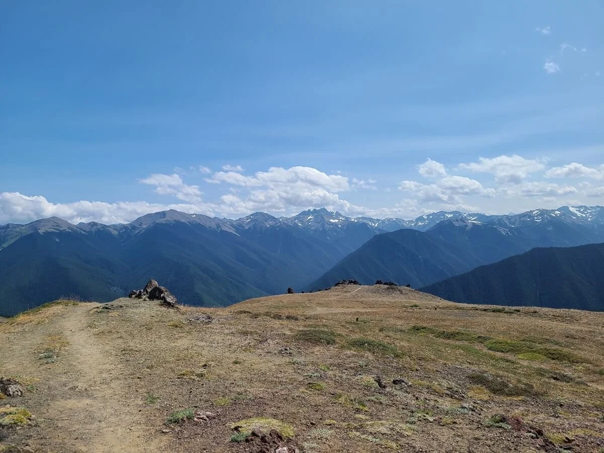
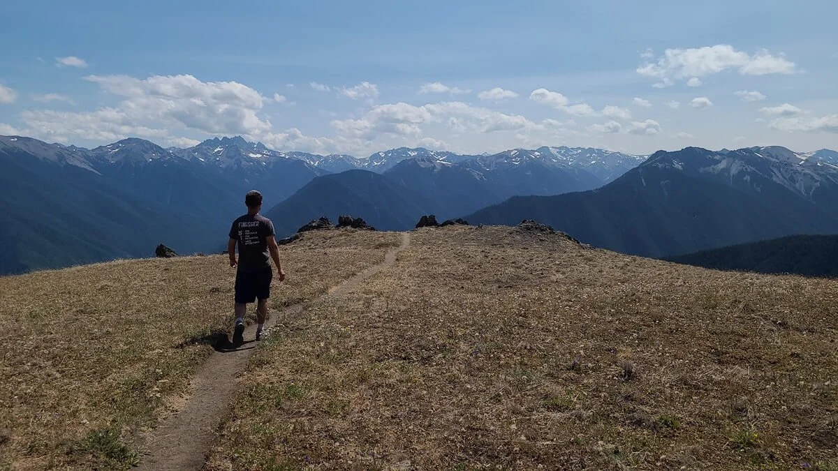
From the viewpoint (seen in the distance), it’s just a little bit more to the top of Blue Mountain, with amazing panoramic views over the Olympic Peninsula
From the top of Blue Mountain, you can see Hurricane Ridge Road weaving its way up to Hurricane Ridge, another popular area in Olympic National Park

From Blue Mountain, you can see Mount Olympus peeking out over the mountains!
After the short summit walk, you’ll find yourself looping back down to get back to the parking lot, but the views continue.

The trail back down the other side of the Rainshadow Trail
Overall, the Rainshadow Loop is a great little trail with amazing views to reward yourself for making the journey up here. You may even get to see some cool wildlife, like marmots, deer, and mountain goats, if you’re lucky!
Other things to do in Deer Park
Aside from the Rainshadow Loop, the top of Deer Park Road is the start of a few different backcountry trails into the Olympic National Park wilderness. From here, you can hike just over 7 miles from Deer Park to Obstruction Point near Hurricane Ridge. This is the highest maintained trail in the park, getting up to 6,100 feet in elevation, and runs through subalpine meadow and forest. Or, you can plan a long backpacking trip across the park that will take you to other regions, such as Staircase, the Buckhorn Wilderness, or the Quinault area. To plan a backpacking trip and reserve backpacking permits, check out the backpacking page on the National Park Service website.
You can also camp in Deer Park if you want to spend the night away from the crowds. The Deer Park campground lies just below Blue Mountain and the main parking area, at 5400 feet, and is a tent-only primitive campground with no potable water or trash cans (make sure to pack out all your trash!), and vault toilets only. This is a first-come first-served campground that costs $15 per night for a site.
Overall, while there isn’t much to do in the Deer Park area, the things that there are to do make the trip well worth it. For us, getting to enjoy the amazing views over the Olympic Peninsula in solitude and away from the crowds was certainly more than worth the sometimes nerve-wracking drive to get here!
Deer Park map
This map of the area shows all the things to do at the top of Deer Park Road.

This map is taken from the National Park Service, and shows the location of the Rainshadow Trail up to Blue Mountain, the Deer Park campground, and the trailhead to hike to Obstruction Point.
Tips for Driving Deer Park Road in Olympic National Park
Here are some extra tips we wanted to share before you start your drive up Deer Park Road in Washington.
Have a confident driver
Deer Park Road is bumpy, twisty and narrow with limited places for pulling over. You’ll definitely want someone driving who isn’t phased by some mountain road exposure, would be comfortable navigating blind turns, and would be prepared to pull over in narrow spaces or back up to a pull off when encountering oncoming cars. Luckily, Kevin fit that description (definitely not me!).
Be respectful of other drivers
Because of the narrow nature of the road and all the blind turns, it’s super important to drive carefully, not just for you but for other drivers as well. As we were heading up, a few cars coming down in the opposite direction were roaring down and flying around the blind turns (which is why I think the road had me so on edge!). Take blind turns slowly and cautiously, and do the same when passing by.
Also, if you are driving extra slowly (that’s ok!) and someone comes up behind you, find a safe place to pull over and let them pass, and then wait for them to get ahead a bit and continue on. If you stay in front of them, you’ll be kicking up a ton of dirt and dust for them that will make it hard for them to see both the road and the amazing views.
Bring some Dramamine
If you know you’re someone who tends to get a little carsick, you might want to make sure you have whatever remedy you take for that on hand. We sound like a broken record here, but Deer Park Road is so twisty! Even while I was just watching back all the video footage I took while driving the road, I felt like I was getting nauseous all over again!
Bring sunscreen and bug spray
The sun can be pretty strong in Deer Park, so make sure to have sun protection, and some bug spray for those pesky flies.
Stay on trail
The meadows in Deer Park and on Blue Mountain are fragile, so be sure to stay on trail to preserve the landscape!
Where to Stay Near Deer park Road in Washington
If you want to stay within 30 minutes of the start of Deer Park Road, you have a few options.
Sequim State Park- Located about 20 minutes from the start of Deer Park Road off WA- 101.
Heart O’The Hills Campground- Located in Olympic National Park on the road up to Hurricane Ridge. It gets great reviews. It’s about 20 minutes from the start of Deer Park Road.
Dungeness Recreation Area- Located on the Strait of Juan de Fuca near Sequim, about 15 minutes from the start of Deer Park Road.
Port Angeles or Sequim- Each town has lodging that will put you 10-15 minutes away from the start of Deer Park Road.
There are tons of places to stay (both camping and lodging) around the Olympic Peninsula. Where you want to stay will depend on where else you want to visit in Olympic National Park and how much time you have. For more information on other things to do in Olympic National Park and where to stay, check out our complete guide to the best things to see and do in Olympic National Park (coming soon!).
Things to Do Near Deer Park Road in Olympic National Park
Looking for other things to do in Olympic National Park? We’re here to help! Check out our other Olympic National Park guides to help you plan your trip.
How to Visit the Hoh Rainforest in Olympic National Park
How to Drive Obstruction Point Road in Olympic National Park
How to Visit Hurricane Ridge + Things to Do
Coming soon:
30+ Awesome Things to Do in Olympic National Park + Complete Guide
10 Day Hikes on the Olympic Peninsula to Add to Your Bucketlist
Olympic National Park Itinerary: One Day to One Week
The Hike to Buckhorn Mountain in the Olympic National Forest
Hiking to Lena Lake: The Complete Guide
More Washington Road Trip Guides
If Olympic National Park is just one step on your Washington road trip, then we have tons more guides to help you plan your trip to other amazing places throughout the state.
MOUNT RAINIER NATIONAL PARK: Check out our favorite hikes in Mount Rainier, and make sure to read our Mount Rainier itinerary and guide to help plan your trip.
MOUNT BAKER WILDERNESS: Learn more about all the amazing hikes near Mount Baker.
NORTH CASCADES NATIONAL PARK: Check out our favorite hikes in the North Cascades, including the Hidden Lake Lookout hike and the Maple Pass hike.
THE ENCHANTMENTS: Learn everything you need to know to hike in the Enchantments (coming soon).
WASHINGTON NATIONAL PARKS ROAD TRIP: Looking to plan a Washington road trip that hits all the National Parks and more? Check out our Washington Road Trip Itinerary to help you plan (coming soon)!
Are you planning to drive Deer Park Road in Olympic National Park? We hope this guide helped, and let us know if you have any questions in the comments below!