How to Drive Obstruction Point Road in Olympic National Park (+ See a Hidden Alpine Lake!)
Obstruction Point Road in Olympic National Park has been called the scariest road in Washington State, but on the flip side, it leads to some of the best views in the entire park! Obstruction Point Road is narrow, winding, and exposed, and you’ll need to know what you’re getting into before attempting this drive. In this guide, we go over everything you need to know to drive Obstruction Point Road in Washington, including when to go, how scary it actually is, things to do at the end of the drive (like finding a hidden electric blue alpine lake!), and more!

Many people put Olympic National Park on their bucketlist to visit the mystical temperate rainforests and rugged Pacific Northwest coastline that make this park so famous. And while these places should absolutely be on your Olympic National Park itinerary, if you’re looking for a unique adventure and a way to get off the well-beaten tourist path…then let us introduce you to Obstruction Point Road!
Obstruction Point Road is Olympic National Park’s highest elevation road, and also one of the most scenic. It leaves from the popular Hurricane Ridge area and winds its way 8 miles through the mountains to Obstruction Point, where you can experience the drier, more alpine regions of the park that are completely different from the popular Hoh Rainforest and rugged coastline on the western half of the Olympic Peninsula. Along the way, you’ll be treated to some of the best views you can get over the Olympic range, including Mount Olympus itself. Sounds great, right?! There’s just one minor caveat…
Obstruction Point Road in Olympic National Park has often been called Washington State’s scariest road, and after having driven it, we can see why! The road is gravel, narrow, and winding, and has quite a bit of exposure that can make even the most confident of drivers a bit nervous. But if you’re up for the adventure, you’ll be rewarded with amazing views, fewer crowds, and a chance to hike some incredibly scenic trails that lie just at the end of those 8 nervewracking miles of road.
Think you’re up for the challenge? In this guide, we’ll go over everything you need to know to drive Obstruction Point Road in Olympic National Park. We’ll cover the best time to go, how to get there, what it’s really like to drive, and give you all our best tips so you know exactly what to expect before hitting the road. So, let’s get to it!
In this Obstruction Point Road guide:
Be sure to check out all our Olympic National Park guides for tons more information to help you plan your trip!
Where is Obstruction Point Road in Washington?

View near Obstruction Point in Olympic National Park
Obstruction Point Road is found on the northern end of the Olympic Peninsula, in Olympic National Park. The start of the road is actually found right in Hurricane Ridge, one of the most popular places to visit in Olympic National Park. From Hurricane Ridge, Obstruction Point Road weaves 8 miles along mountainsides through the backcountry to Obstruction Point, where stunning views and hiking trails await.
How to Get to Obstruction Point Road in Olympic National Park
To get to Obstruction Point Road, you’ll enter Olympic National Park through the Heart O’the Hills entrance station which provides access to the Hurricane Ridge area.
From the town of Port Angeles (often called the gateway to Olympic National Park), take Hurricane Ridge Road, which travels 18 miles up to the Hurricane Ridge parking lot. Along the way, you’ll enter the park through the Heart O’the Hills entry gate and have to pay the entrance fee (or show your previously purchased park pass). The Olympic National Park pass costs $30 per car and is good for 7 consecutive days in the park. Tip: If planning on visiting more National Parks within the year, consider purchasing the Annual America the Beautiful Parks Pass, which gets you into all National Parks and Federal Recreation Areas for free! We used it to get into other places on our Washington road trip, such as the Mount Baker Wilderness, the Enchantments, Mount Rainier, and other places in Olympic National Forest!
Hurricane Ridge Road is a great precursor to Obstruction Point Road. As you climb to 5,200 feet, views of the Olympic Range start to open up. However, this road is entirely paved and safe, with guardrails in place in the more exposed areas, and several large pull-offs where you can stop to enjoy the view.

The view from the car on Hurricane Ridge Road in Olympic National Park
The road ends at the parking area for Hurricane Ridge. Just as you enter the parking area, the start of Obstruction Point Road will be to the left. Look for a signpost marking its start- it will be a gravel road that dips down off the main paved road.
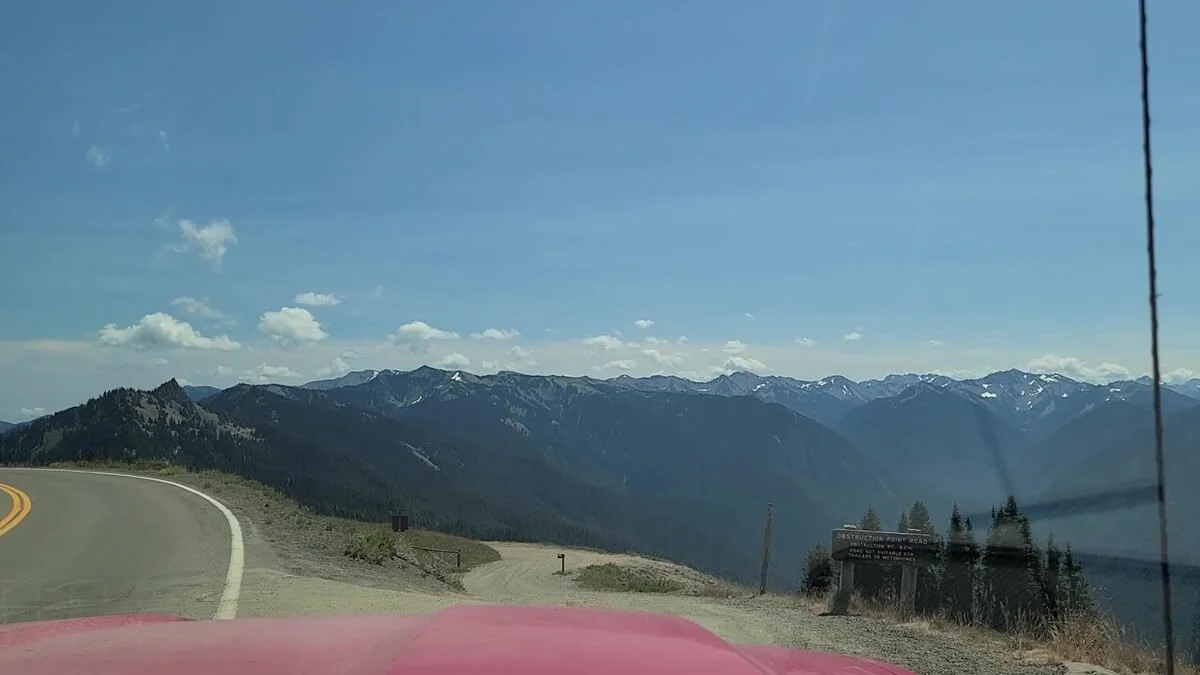
The start of Obstruction Point Road near Hurrican Ridge
Obstruction Point Road Map
This map of Olympic National Park shows where Obstruction Point Road is in relation to other places in the park.

This map taken from the park brochure shows the northern portion of Olympic National Park. We’ve highlighted where Obstruction Point Road is, and you can see where it is in relation to other popular places like Port Angeles, Hurricane Ridge, and Lake Crescent.
When is Obstruction Point Road Open?
Because it’s a high elevation mountain road, Obstruction Point Road does close in the winter. Typically, Obstruction Point Road is open from early/mid-July to mid-October, depending on the conditions that season. It can also close at any time if road conditions are bad. Be sure to check road status and conditions before heading out to make sure that Obstruction Point Road is open before you go.
How Long Is Obstruction Point Road in Washington?
From Hurricane Ridge to Obstruction Point, Obstruction Point Road is 8 miles. It sounds short, but as you’ll see in just a bit, you’ll have to take it slow. It took us about 30 minutes to drive going at a cautious speed and without any stops.
What Kind of Car Do I Need to Drive Obstruction Point Road in Washington?
Obstruction Point Road is entirely gravel, and while overall it’s actually pretty well-maintained for a mountain road, it can get pretty bumpy, rutted, and washboarded in places, particularly on the steeper parts of the road. We do recommend having a 4WD vehicle just as a precaution so you don’t get stuck in any unwanted situations. We had a truck and Kevin liked having and being able to use the 4WD functionality, particular for the steeper climbs along the drive. It’s more of a peace of mind thing than an absolute necessity, though again, we do highly recommend it. That said, we have read accounts of people doing it in normal cars, and we saw a couple of them at the lot at the end of the road when we were there (though the majority of vehicles were trucks and SUVs), so it’s definitely possible.

Obstruction Point Road can get steep and rutted in places
Is Obstruction Point Road Scary to Drive?
One of the biggest questions about this backcountry drive inevitably is…how scary is Obstruction Point Road, and is it really dangerous?
Getting a title like “the most dangerous road in Washington” shouldn’t be ignored, and I will say that I can see why it got this label.
Obstruction Point Road is a true mountain road. It twists and turns its way into the mountains and alongside mountain slopes, which means that many parts of the road have some serious exposure, with drop-offs on one side. Take this, along with the fact that the road is quite narrow and can get a bit rough and bumpy, and you have yourself the perfect combination for a nervewracking, white knuckle drive.

A view of Obstruction Point Road from the car…it’s narrow, exposed, and full of blind turns
If you want to drive Obstruction Point Road in Washington, here are some things you should know:
Make sure to have a confident driver that isn’t really phased by exposed mountain roads.
Be prepared to handle two-way traffic. Obstruction Point Road is often quite narrow, and luckily there are frequent spaces where you can pull over to let oncoming traffic pass. Sometimes, you won’t be lucky enough to be at the right spot at the right time, and you may have to do some backtracking to find a good space to pull over. Though Obstruction Point Road is off the heavy tourist path, this road still does see a decent amount of cars, so expect to have to maneuver around others frequently. Keep your eyes ahead for cars and always be on the lookout for places where you can pull over safely.
Because Obstruction Point Road twists and turns through the mountains, there are also several blind turns. So make sure to drive slowly and cautiously when approaching these turns.
Despite its claim to fame, I wouldn’t personally say that Obstruction Point Road was the scariest road we drove on in Washington. For me, that title goes to the road we drove just the day before…Deer Park Road. Deer Park Road is a similar mountain road with exposure, ruggedness, and narrow sections. But what made that road so much worse for me was the sheer number of blind turns along that drive…there were so many! I was on edge the entire time, and on more than one occasion, our hearts jumped from surprise traffic in the opposite direction.
Though Obstruction Point Road is more exposed, a bit rougher and bumpier, and way busier than Deer Park Road, the blind turns on Deer Park Road were way more frequent and made that drive feel so much scarier. It also could just be because we got a good taste of what Obstruction Point Road would be like by driving Deer Park Road first, so by the time we drove it, Obstruction Point Road didn’t seem as bad!
That said, we can safely say that Obstruction Point Road can be a bit scary, especially for those not comfortable with heights or exposure, or for those not used to driving these kinds of mountain roads. If you’re unsure, be sure to take a look at our Obstruction Point Road description below and feel free to ask us any questions about the experience!
Is There a Fee To Drive Obstruction Point Road in Washington?
To drive Obstruction Point Road, you’ll need to have an Olympic Park Pass, which costs $30 per vehicle. You can buy it as you enter through the Heart O’the Hills entrance station on the way to Hurricane Ridge, or at any other entry gate in the park. It’s good for 7 consecutive days in Olympic National Park.
Driving Obstruction Point Road: Our Experience
Now that we got some of the details out of the way, we want to share our experience driving Obstruction Point Road in Olympic National Park to help you decide if this drive is something you want to tackle! We will say that it’s kind of hard to capture the true exposure and scary nature of this drive in pictures, particularly through a dusty windshield, but we’ll do our best to convey what it’s like to drive to Obstruction Point!
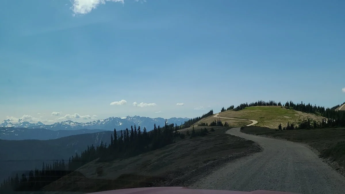
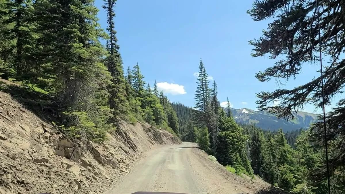
After a quick visit to the Hurricane Ridge Visitor Center (this sadly doesn’t exist anymore due to a fire), we ventured over to the start of Obstruction Point Road. From the Hurricane Ridge lot, the gravel road dips down and heads around a corner, where the scariness of the road is already revealed, making both of us let out a sigh of “oh boy…”. Unlike Deer Park Road which we drove the day prior, Obstruction Point Road starts right off the bat being narrow with exposure, and you can see the road winding its way along the mountain slopes ahead.

The beginning portion of Obstruction Point Road

The views start early on Obstruction Point Road
Views of the Olympic Range will be to your right as you navigate the narrow gravel road. These views are interspersed with brief stretches of treelined section of road that help to take the edge off a little, and in the peak of summer, may be lined with beautiful purple wildflowers.

Mountain views from Obstruction Point Road (Mount Olympus is in the center)

Some parts of Obstruction Point Road head through the trees
Though Obstruction Point Road is a bit off-the-beaten-path, it still does see quite a bit of traffic, so definitely expect to see a good number of cars coming from the other direction. Often, the road is just wide enough to sneak past eachother, and there are a good number of pull-off areas carved into the side of the road. Keep your eyes ahead to spot oncoming cars and to give yourself enough time to find a good and safe spot to pull over and avoid having to backtrack to one.
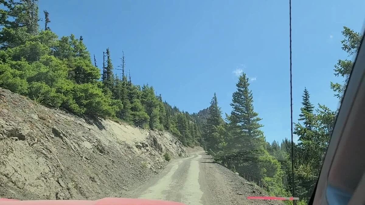
When we drove it, Obstruction Point Road was in pretty good condition for the most part, and we found it surprisingly smooth for a mountain road, though on some of the steeper climbs of the drive, it did get a bit bumpy and washboarded. There were some blind turns on the drive as well- so take these slowly and be prepared for oncoming cars when navigating these- but thankfully there were also a lot of straight sections of road where you can easily see oncoming traffic, unlike Deer Park Road which felt like it was made up mostly of these blind turns.

A particularly narrow section of Obstruction Point Road, with some brief exposure on both sides
A view of Obstruction Point Road with some good exposure on the right

There are quite a few blind turns along Obstruction Point Road!
Being in the passenger seat, I admit I was nervous, especially when I could look out my side window and see the road disappear over the edge just inches away, but to be honest, I was focusing on the constant scenery and letting that distract me from being too scared, and I trusted Kevin’s driving skills!

This is the view looking down out my passenger side window- it gives an idea of the exposure that you’ll be driving along on Obstruction Point Road!
Narrow, exposure, and a blind turn ahead!

Navigating the blind turns of Obstruction Point Road

The view of the Olympic Range can be seen almost the entire way on Obstruction Point Road

Our favorite spot along Obstruction Point Road where the road turns to face this amazing mountain view!
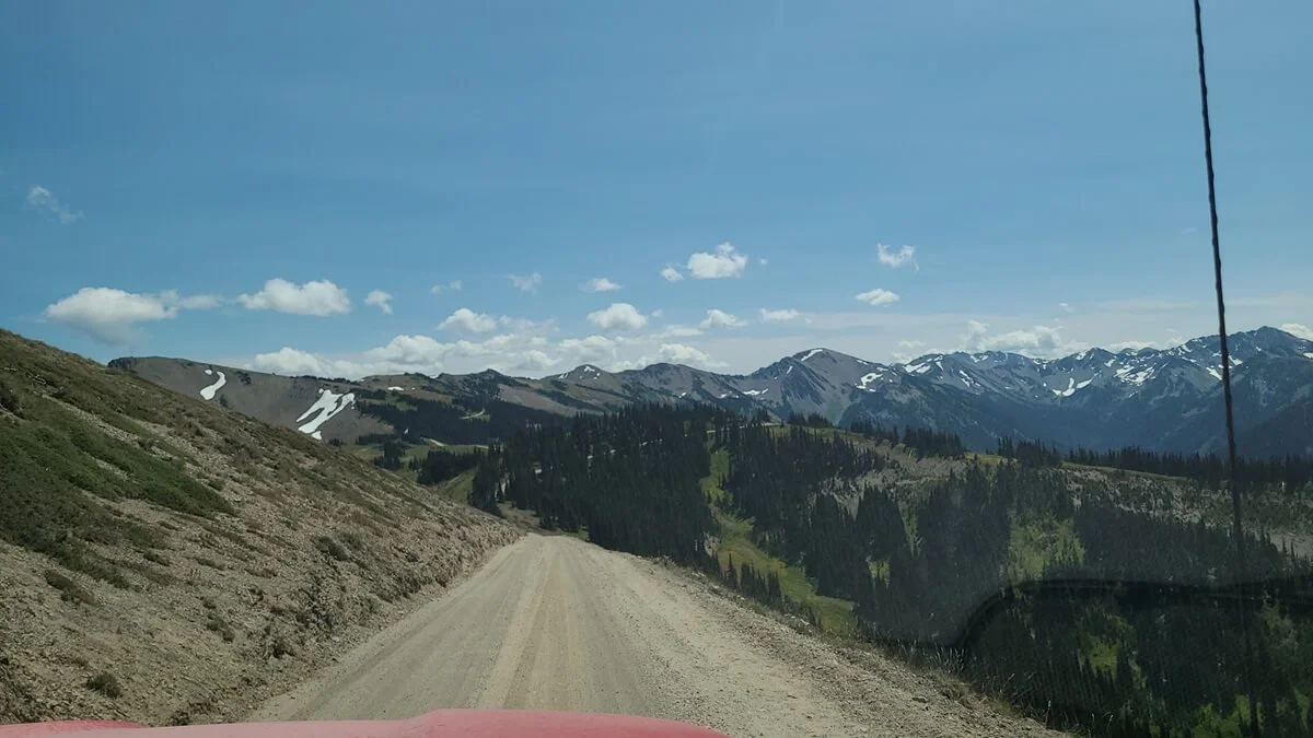
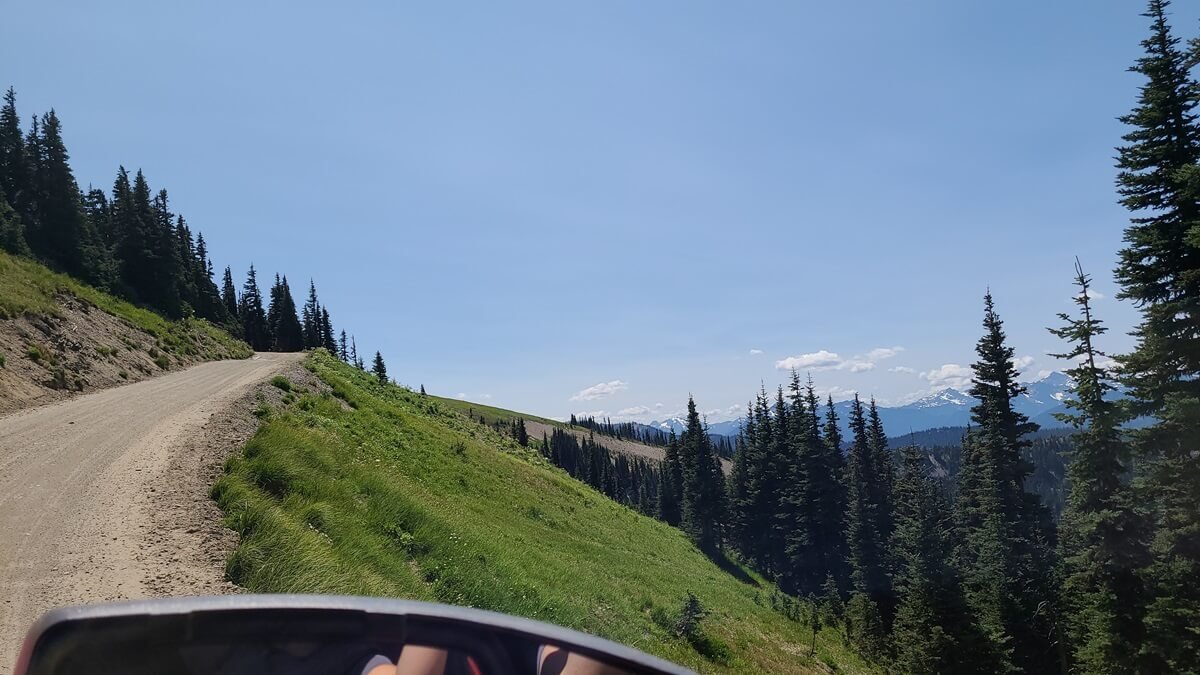
Fortunately, we would say that once you are about two thirds in on Obstruction Point Road, the drive does mellow out a little bit, and you can breathe a sigh of relief as the worst parts are behind you. The exposure starts getting a little less, and eventually, you’ll find yourself driving through more of a meadow-like landscape with no steep drop-offs. The road is still narrow and bumpy, but not having that exposure makes it much better to navigate, and the scenery just keeps getting better and better!

Towards the end of the drive, Obstruction Point Road mellows out as it weaves through subalpine meadow


A view of the Olympic Mountains towards the top of Obstruction Point Road
Obstruction Point Road ends after 8 miles in a small lot that fits about 25 cars, though cars were lining the right side of the road leading up to the lot. There’s a vault toilet and a trailhead up here, and that’s about it (well, aside from the amazing views!). But give yourself a giant pat on the back, because you made it!

The parking lot at the end of Obstruction Point Road
Things to Do at Obstruction Point in Olympic National Park

Perfect views of Mount Olympus from Obstruction Point!
So, you made it to Obstruction Point…yay! Now what?
Well, there’s really only one thing to do once you get to Obstruction Point, and it just happens to be our favorite thing to do…hike!
And the really great thing about hiking up here was that even though Obstruction Point Road itself seemed a bit busy, and even through the parking lot was full, we barely ran into anyone out on the trails. So it really does feel a bit off-the-beaten path once you get beyond the parking lot.
There are two main trailheads at Obstruction Point:
One trail heads east, splitting rather quickly to two different destinations. The first goes to Deer Park. This trail is the highest maintained trail in Olympic National Park and is a point-to-point hike that ends at Deer Park at the end of Deer Park Road. You’d have to arrange your own transportation between trailheads if you were to do this, or, because it’s only about 7.5 miles one way, it can be done as an out-and-back from Obstruction Point to make a very long day hike. The other split in the trail leads to the Badger Valley Trail, which goes out to the scenic Grand Lake about 4.5 miles from the trailhead.
The second trailhead at Obstruction Point follows the Lillian Ridge Trail just over 3.5 miles to Grand Lake.
When we drove Obstruction Point Road, we had a late start in the day, still needed to explore the trails of Hurricane Ridge later that afternoon, and also, admittedly, didn’t really have a plan for hiking in the Obstruction Point area. We kind of thought we’d just experience the drive and enjoy the scenery at the top for a little bit before heading back down. This is something we do regret, though, and we wish we had planned to spend more time hiking the trails around Obstruction Point! So if there’s one piece of advice we’d give you, it’s to plan for a whole day adventure out here. Give yourself plenty of time to experience the rewards of tackling Obstruction Point Road, because the scenery and hiking out here truly is amazing.
We did at least give ourselves a little bit of time to explore while we were up here. We decided to just head a little ways down the Lillian Ridge Trail for a bit to see where it got us and to enjoy the scenery from the trail, and we’re so glad we did! The scenery out here is absolutely gorgeous, and made us wish we had planned for more hiking time up here. In fact, even though we didn’t hike it entirely, the Lillian Ridge Trail at Obstruction Point had some of our favorite views in Olympic National Park, and was probably our favorite trail in the whole Hurricane Ridge area! We admired views of Mount Olympus, and even stumbled upon an amazing view over a small hidden electric blue lake tucked into a valley below.
Want to learn more about the Lillian Ridge Trail? We’ll share the details now!
Lillian Ridge Trail to an Alpine Lake Viewpoint
The Obstruction Point trailheads are found at the far end of the parking lot, marked by a sign. Follow the trail to the right heading towards Grand Lake, Moose Lake, and Grand Pass. To get to the view of the electric blue lake, you’ll only be hiking about 0.9 miles up the trail, but if you have the time, we definitely recommend you continue beyond to Grand Lake!

Follow the sign towards Grand Lake
Here is our elevation profile of the hike on Lillian Ridge out to the viewpoint and back. In total, it was about 1.9 miles roundtrip, with 360 feet of elevation gain.
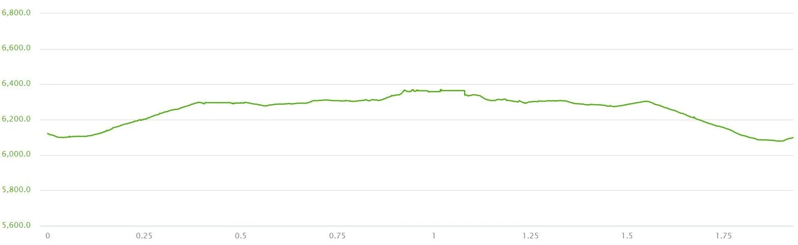
Elevation profile of our roundtrip hike on the Lillian Ridge Trail at Obstruction Point
Right from the trailhead, you can see the Lillian Ridge Trail climb its way to the top of a small hill ahead. As you make your way up this steady climb, views of the Olympic Range are stunning, with Mount Olympus in clear sight, and I’m pretty sure I stopped about every ten steps to take pictures. To your left, you’ll see the Badger Valley and Deer Park Trails weaving their way across the landscape.

The start of the Lillian Ridge Trail climbs a small hill through subalpine meadow

Awesome views of Mount Olympus are found along the entire Lillian Ridge Trail!

The steady climb up through the subalpine meadow

Looking back toward the Obstruction Point parking lot
At the top of the climb, the trail flattens out as it crosses a picturesque meadow. From up here, views of the Olympic Range continue, and you can also see the top of Obstruction Point Road making its last few turns up to Obstruction Point.

Traversing the flat meadows at the top of the climb

A view back over Obstruction Point Road

Loving these views of Mount Olympus from our Obstruction Point hike!
Ahead, the trail wraps around a small snow patch, climbing just a little bit more to the top of another ridge as it starts to become a little bit rockier. From this new vantage point, you get amazing views into the valley ahead. You’ll see the trail continue down a set of stone steps and if you look ahead, you can see the Lillian Ridge Trail stretch straight out across a ridge as it heads to Grand Lake.


Admiring the view from the trail before it heads down a rocky staircase to the meadow below
However, this is where we stopped our hike to Grand Lake, and instead made the slightest of detours that gave us a huge payoff.
At this point, just above the snow patch and before you start descending down the stone steps, there will be a small rocky point. Kevin eyed it a bit, wondering if there were better views from the top. But, we also didn’t want to go off-trail and stomp across the meadows (remember to Leave No Trace up here!). After some investigating, he found a herd path along the left-hand side of the rocky point. It traversed alongside a snow patch, and became a very evident dirt path that headed toward the “summit” of the small peak. I let Kevin investigate while I relaxed and enjoyed the views on the trail, but before I knew it, I looked up and Kevin was standing on the summit waving for me to come up. And I am sure glad he did!

Can you see Kevin on top of the rocky point on the left?

The herd path that wraps around the left side of the rocky point
Along the little herd path on the other side of the small point, views down into the opposite valley opened up, and a small blue lake came into view. While this lake was super cool to see, there was another waiting for me when I got to the top.

A beautiful blue lake tucked into the valley below comes into view!
The herd path ends at the bottom of a small boulder pile that forms the top of this rocky summit, so you’ll have to navigate up through this, but it’s a short little climb. And when you get to the top, stunning 360 degree mountain views open up. And the best part? This view of a stunning electric blue lake below.

Looking up the boulder pile near the top of the small hill

The amazing view of the lake at the top! This was definitely one of our favorite views in all of Olympic National Park.
This spot was such a great little find…you can look back and see the trailhead, parking lot, and parts of Obstruction Point Road, then look out to the West to see Mount Olympus and the Olympic Range, and also look out to the east over endless mountain views and blue lakes.

Looking out over the Olympic Range and Mount Olympus
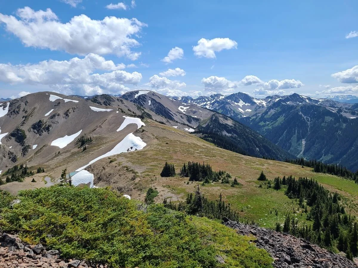
Looking out towards the Grand Lake area
If you only have a little bit of time after driving Obstruction Point Road, we definitely recommend hiking at least out to this point along the Lillian Ridge Trail. It’s relatively easy and quick, and it led us to our favorite view in Olympic National Park.
From here, you can continue the trail to Grand Lake, or simply retrace your steps. It will be all downhill back the car.
Backpacking Obstruction Point
While you can do day hikes on the trails at Obstruction Point to either Deer Park or Grand Lake, these trails also go further into the backcountry for the start of a multiday hiking trip.
Beyond Grand Lake, you can hike to Grand Pass and across the interior portion of Olympic National Park to connect with other places such as the Staircase region and the Quinault Rainforest.
To find backcountry sites, plan your trip, and get backpacking permits, head to the National Park Service site.
Tips for Driving Obstruction Point Road in Washington

Here are a few more tips we have for driving Obstruction Point Road in Olympic National Park.
Drive Obstruction Point Road on a weekday
If possible, avoiding weekends will be helpful when driving Obstruction Point Road. During peak times (primarily weekends in the summer), you may find yourself waiting to get through the Heart O’the Hills entrance station as cars are held and metered in. We definitely recommend heading to the park early on a weekend (before 10 am), or going on a weekday (we visited Hurricane Ridge midday on a Tuesday in July and had no issues) to avoid this.
Another reason to drive Obstruction Point Road on a weekday versus a weekend is because there will likely be less traffic along the road. When we drove the road on a Tuesday, there was still a bit of two-way traffic, but we can imagine it would be much higher volume on a weekend. If you’re nervous about this or would just rather feel safer when crowds are lower, then choosing a weekday to drive Obstruction Point Road would be a good idea.
Bring plenty of food and water
Since the Hurricane Ridge visitor center and lodge burned down, Hurricane Ridge has no facilities other than bathrooms. Similarly, at the end of Obstruction Point Road is just a vault toilet. If you plan on spending the whole day at Obstruction Point or at both Obstruction Point and Hurricane Ridge, make sure to pack all the day’s food and water with you.
Be courteous of other drivers
Be sure to drive cautiously, not just for you but for others on the road. Take blind turns slowly, and pull over when possible to let others go by. Also, if a car comes up behind you that seems to be going faster than you are comfortable going, find a safe place to pull over and allow them to drive by. That way, you won’t spend the rest of the time kicking dust and dirt at their windshield that will make it harder for them to see the road and the views!
Clean your windows
Make sure to have a nice clean windshield before you drive Obstruction Point Road, which will help you see the road better and reduce the glare.
Wildlife at Obstruction Point
Up in the alpine environment, you might encounter marmots, elk, deer and more! When we visited, there was even a sign warning of habituated mountain goats that can become aggressive. Be sure to keep a safe distance from all wildlife, stay on trails, and leave no trace to avoid unwanted encounters and preserve the fragile area!
Where to Stay Near Obstruction Point Road in Washington
The best place to stay near Obstruction Point Road is the town of Port Angeles, which is often called the gateway to Olympic National Park and sits right at the foot of Hurricane Ridge. From town, you’re about 15 minutes from the Heart O’the Hills entrance station.
Sequim, another popular Olympic Peninsula town, is about a half hour from the entrance gate, sitting east of Port Angeles on WA-101.
The Lake Crescent Lodge, found at another popular Olympic National Part spot, is about 35 minutes from the entrance, and located west from Port Angeles on WA-101.
If you’re looking to camp, the Heart O’the Hills campground, found right near the entrance gate to Hurricane Ridge, is your best bet and gets great reviews.
The Fairholme Campground is found at Lake Crescent, and the Dungeness Recreation Area is found close to Sequim.
There are actually a lot of options for staying on the Olympic Peninsula, both inside and outside Olympic National Park, and where you will want to stay will depend on where else in the park you want to visit and how much time you have. For a better idea of all your options for staying in Olympic National Park, be sure to check out our Olympic National Park Guide + Things to Do (coming soon)!
Things to Do Near Obstruction Point Road in Olympic National Park
Looking for more things to do before or after your drive on Obstruction Point Road in Olympic National Park? Check out all our Olympic National Park guides for more info and tips!
How to Visit the Hoh Rainforest in Olympic National Park: The Complete Guide
A Guide to Hurricane Ridge in Olympic National Park
How to Drive Deer Park Road in Olympic National Park + Things to Do
Coming soon:
Things to Do in Olympic National Park + Complete Guide
Olympic National Park Itinerary: One Day to One Week
Best Hikes on the Olympic Peninsula
Hiking to Lena Lake in Olympic National Forest
How to Hike Buckhorn Mountain: Our Favorite Hike on the Olympic Peninsula!
More Washington Travel Guides
Heading out on a Washington road trip? We got you covered! Check out more of our Washington travel guides to learn more about the National Parks and other amazing sights in this state.
MOUNT RAINIER NATIONAL PARK: Learn more about our favorite hikes in Mount Rainier, including the Burroughs Mountain Trail, the Mount Fremont Lookout Trail, the Tolmie Peak Trail, and the Skyline Loop Trail. Also, learn how to combine everything into an amazing Mount Rainier itinerary, or learn how to visit Mount Rainier in just one day.
NORTH CASCADES NATIONAL PARK: Check out the Hidden Lake Lookout Trail in the North Cascades.
MOUNT BAKER WILDERNESS: Learn more about our favorite hiking trails near Mount Baker.
Are you interested in driving Obstruction Point Road in Washington? We hope this guide helped you prepare and gave you an idea of what to expect, and feel free to ask us any questions in the comments below!